
SOLD: 20 Acres with Mineral Rights in Pecos County, TX 🛢️📈💰
50% Interest in 40 NMA
HBP @ 12.5% | 0.0625 RI
Payment Options

Payment Note(s)
🛑 CASH ONLY! No payment options are available for this property.
How to Purchase: Please click the ☝️ orange “RESERVE NOW” button above to make your secure deposit payment via credit card or debit card. Once you’ve completed checkout, we will both receive instant email notification of your deposit, and the deposit will be credited towards the cash price at closing. Properties are sold on a “first deposit, first sold” basis.
$99 Option Fee: All property deposits are subject to a NON-REFUNDABLE $99 Option Fee. Please see our Refund Policy for more information. Buyer will have up to seven days to sign the contract.
Contract: After making your initial deposit, we will email you the purchase and sale agreement, which includes a special warranty deed. Contracts are manually prepared and reviewed and will be sent out Monday through Friday between 9 AM and 5 PM CST.
Closing: This interest will be sold with a 14-day closing.
Description
Mineral rights!
This is a 50% mineral interest in a 40-acre tract in Pecos County, TX. This is for minerals only; no surface rights!
40 acres x 50% ownership = 20 NMA/NRA
40 acres x 50% ownership x 12.5% Royalty = 0.0625 RI
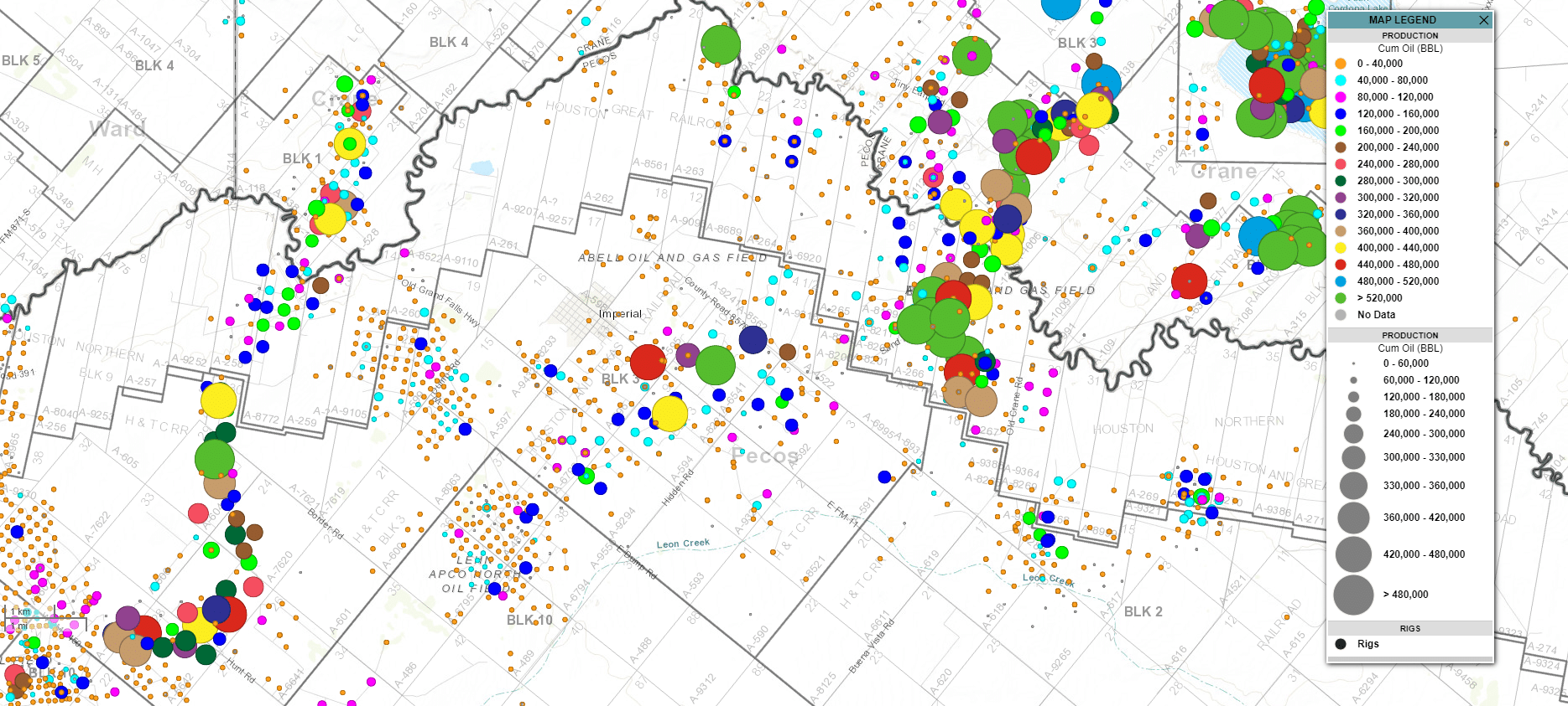
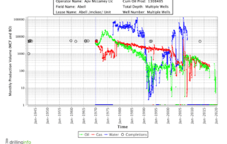
Current Operator: APV McCamey LLC, PO Box 1440, McCamey, TX 79752
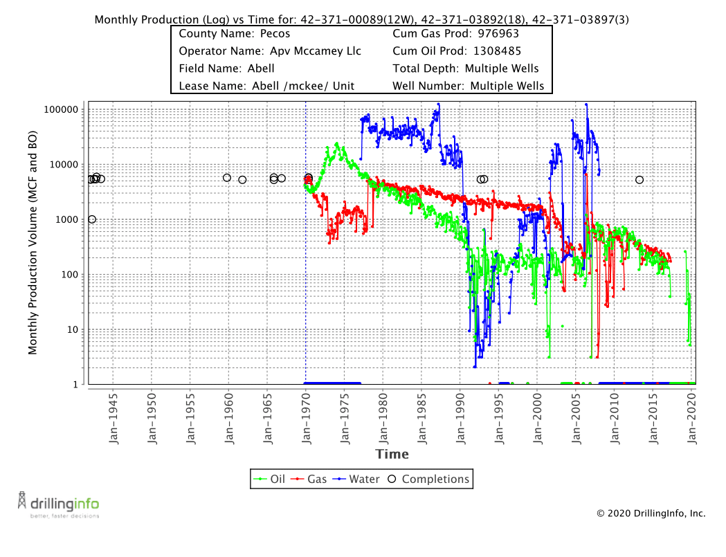
Well: ABELL /MCKEE/ UNIT 11W (API: 42-371-00070)
🛢️ Production: 1,308,485 BBLS & 976,963 MCF (Through 12//2019) 🛢️
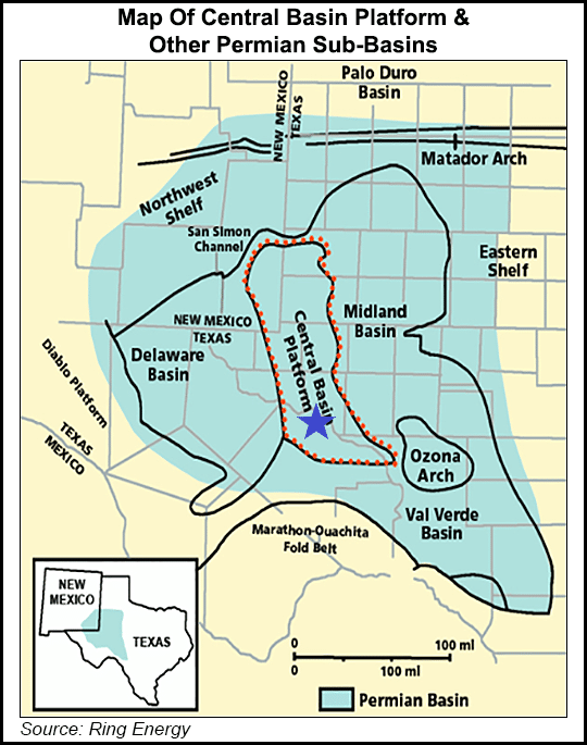
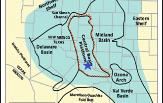
SAN ANDRES-CLEARFORK, CENTRAL BASIN PLATFORM, AND OZONA ARCH PLAY
The definitive characteristics of this play are: (1) a setting on the Central Basin Platform, (2) dolomitized shallow-water carbonate platform facies with an admixture of silicate sands, and (3) very effective seals provided by evaporite facies. The major drawback for future exploration success of this play is its extensive drilling history.
The play includes oil and subordinate gas accumulations in stratigraphic/structural and structural traps in a platform sequence of carbonate and, to a lesser extent, fine-grained silicate reservoirs of Permian age. The play area is approximately 200 mi long and 110 mi wide and covers all of the Central Basin Platform and the Ozona Arch; it is bounded on the west and south by the Delaware-Val Verde Basins, and on the east by the Midland Basin. Maximum thickness of Permian sedimentary rocks is less than 10,000 ft.
Reservoirs: Reservoir rocks consist of porous and permeable dolomitized carbonates, limestone and fine-grained sandstone. They include skeletal grainstones, dolomite, limestone, calcareous and silty sandstones, sponge and algal dolomitized limestone, dolomitized mud and wackestone, and vuggy to cavernous carbonate beds. Carbonate rocks were deposited in open to restricted platforms and platform margins associated with sea-level fluctuations, shelf-margin reef development, evaporites, and sabkha deposits. Reservoir quality is enhanced by selective dolomitization, dissolution, fracturing, and leaching. Reservoirs are contained in the Permian Guadalupian San Andres, Grayburg, Queen, Seven Rivers, and Yates Formations; they also occur in the Clear Fork and Wolfcamp Formations. Individual reservoir thicknesses may range up to hundreds of feet; overall porosities average 12 percent and permeabilities average 18 mD. Drilling depths vary from 1,000 to 10,000 ft.
Source rocks: Source rocks include indigenous organic-rich calcareous shale and shaly limestone of Wolfcampian and Leonardian age. Important additional source contributors are the Late Devonian Woodford Shale and organic-rich Pennsylvanian and Permian shales in basins adjacent of the Central Basin Platform. Hydrocarbon generation from adjacent organic-rich source rocks probably occurred during Upper Permian time. Fluids migrated laterally and upward into the present reservoirs.
Timing and migration: The combined stratigraphic/structural traps containing the hydrocarbons of this play were all in existence by the end of Permian Guadalupean time. Mature source rocks were present in the adjacent Delaware, Val Verde, and Midland Basins at this time. It seems likely that these hydrocarbons traveled upward along a combination of faults, unconformities, and permeable stratigraphic horizons into the Permian reservoirs of this play from the time of their inception. Secondary migration into and out of these traps may well continue to the present day.
Traps: Primary trapping mechanisms are generally a combination of structural and stratigraphic features such as anticlinal noses and domes, that are associated with stratigraphic depositional and diagenetic facies changes. Large, simple anticlinal closures also are present. Seals consist of impervious dolomite, shaly carbonate, anhydrite, and other evaporite facies. Structurally and stratigraphically trapped hydrocarbons occur at depths of 1,000-10,000 ft and average 4,500 ft.
Exploration Status: Through 1990, cumulative production from this play was 11.6 BBO, 26.7 TCFG, and 1.7 BBNGL, making the play the most important producer in the Permian Basin Province. The largest oil field, Yates, discovered in 1926, has produced more than 2 BBO. Eunice Area, discovered in 1929, has produced 850 MBO and 8.8 TCFG. Most of the major discoveries in this play occurred prior to 1950.
Property Information
Parcel Size
40
State
Texas
County
Pecos
Nearest Cities
Imperial, TX
Parcel #
n/a
Address
Sand Road & Hidden Road, Pecos, TX 79743
Legal Description
NW/4 NE/4 of Section 5, Block 3, A-592, H&TC RR Co Survey, Pecos County, TX
Features
Acres
40
Dimension
1320′ x 1320′
County
Pecos
Access
Lease Road
Power
Yes
Coordinates
31.258645, -102.648405
Elevation
2,380 FT
Purchase Information/Fees
$249
Document Fee
At closing, Buyer will pay a $249 document preparation fee, which includes postage and recording fees.
🕵️ Still looking for land in Texas?
⭐ Please take a look at our other remarkable properties 👉 HERE!